skip to main | skip to sidebar

Monday, October 13, 2008

Unstandardized choropleth Maps


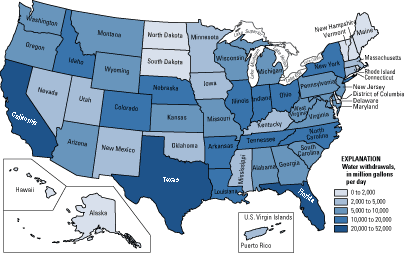
Unstandardized Choropleth Maps utilize data sets of raw numbers. The data displayed is not averaged but is represented as a total value.The above unstandardized Choropleth map dispays the number of water withdrawals by state across the US.
http://pubs.usgs.gov/fs/2005/3051/images/2000choropleth.gif
Posted by Molly Rose at 8:32 AM

No comments:

Post a Comment

Newer Post Older Post Home
Subscribe to: Post Comments (Atom)

Molly's Map Catalog - GIS 3015

Blog Archive

  • ▼  2008 (54)
    • ►  November (5)
    • ▼  October (19)
      • Histogram
      • Parallel Coordinate Graph
      • Triangular Plot
      • Windrose
      • Climograph
      • Population Profile
      • Scatterplot
      • Index Value Plot
      • Accumulation Line Graph or Lorenz Curve
      • Bilateral Graph
      • Google Earth - Remote Sensing
      • Nominal area Choropleth Map
      • Unstandardized choropleth Maps
      • Standardized Choropleth maps
      • Univariate Choropleth Maps
      • Bivariate Choropleth maps
      • Unclassed Choropleth Maps
      • Classed Choropleth Maps
      • Range Graded Proportional Circle Map
    • ►  September (26)
    • ►  August (4)

About Me

My photo
Molly Rose
View my complete profile