skip to main | skip to sidebar

Tuesday, September 23, 2008

Isoplaths

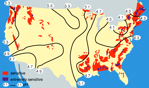
An isoplath map is a type of contour line map that uses lines to connect areas of equal acidity's. These contour lines are known as isoplaths, hence the term "isoplath map." An example of an isoplath map is shown below:
http://www.globalchange.umich.edu/globalchange1/current/lectures/kling/water_nitro/USAacid_rain2.gif
Posted by Molly Rose at 6:57 AM

No comments:

Post a Comment

Newer Post Older Post Home
Subscribe to: Post Comments (Atom)

Molly's Map Catalog - GIS 3015

Blog Archive

  • ▼  2008 (54)
    • ►  November (5)
    • ►  October (19)
    • ▼  September (26)
      • DLG
      • Continuously Variable Proportional Circle Map
      • DOQQ
      • DEM
      • DRG
      • Isopleths
      • Isoplaths
      • Isohyets
      • Isotachs
      • Isobars
      • LIDAR
      • Doppler Radar
      • Black & White Aerial Photo
      • Infrared Aerial Photo
      • Cartographic Animations
      • Statistical Maps
      • Cartograms
      • Flow Maps
      • Isoline map
      • Proportional Circle Map
      • Choropleth Map
      • Dot Distribution map
      • Propaganda map
      • Hypsometric map
      • PLSS Map
      • Cadastral Map
    • ►  August (4)

About Me

My photo
Molly Rose
View my complete profile